
History, Details & More Boring Stuff
THIS IS A WORK IN PROGRESS
page update: 19th. November, 2026
Universal [as in, of the Universe] and Global overview, a great & gentle oversight & introduction as to how the planet earth works: Lovelock, James: GAIA The Practical Science of Planetary Medicine
Basic technical data: Burberry, Peter: Environment & Services - only the first 50pages or so apply to worldly matters.
If you are concerned about the flight of birds or the entrails of goats, you should read
Vitruvius [people once said we went to school together].
Vitruvius is a bit of a dude, even the odometer gets a mention.
Marcus Vitruvius Polio writes about the octagonal wind tower of Athens. [see ref. under]
We oft hear the expression: "Since records began".
[Met Office historic data: https://www.metoffice.gov.uk/research/climate/maps-and-data/historic-station-data ]
Leeds Weather Data:
https://weatherspark.com/h/y/42012/2025/Historical-Weather-during-2025-in-Leeds-United-Kingdom
[All the Information is there, but not in he most accessible form, particularly the "degree days" being presented as growing or cumulative, rather than daily and then the annual total.]
The Earth is not flat [and it never was]. And the sea ain't level.
newtons weather station?
Wind:
Beaufort did not have a digital anemometer, his observations are subjective.
[There is a PhD in this, about instrumentation, etc.]
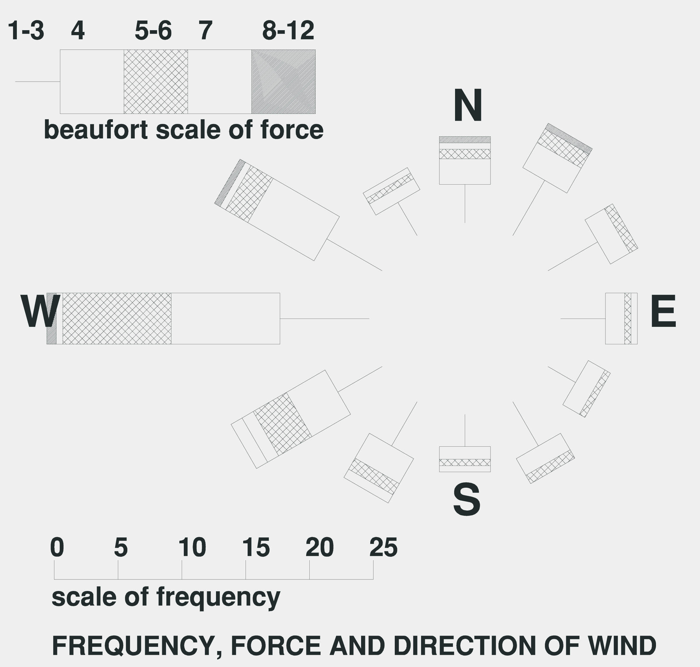
This is the wind-rose for Leeds drawn from regional data about 35years ago.
The 'wiki' description:
https://en.wikipedia.org/wiki/Wind_rose
Scroll down a little to 'History' for older indications of a 'wind rose'.
How I laughed, according to wiki, the first known reference to an anemometer is 1450.
Described by Alberti [Leon Battista], I have a facsimile of his 'Ten Books' on my shelf
and I don't recollect reading that.
It looks like a portable 'four cup' anemometer was invented in 1846 [wiki]
mitchells chart
Onshore winds will affect tide height [and the converse].
Global Wind Systems:
Rain:
Charts
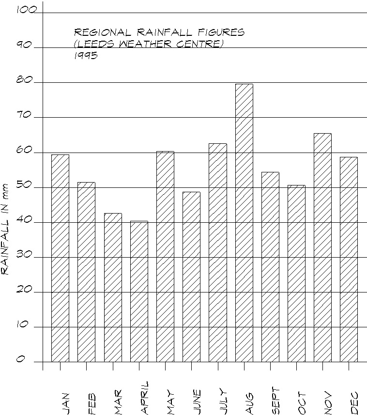
This is the annual rainfall figures from Leeds weather centre in 1995 - yes, it rained more in August than it did in April.
[I'd like to get hold of useful 2026 figures to update this bar chart.]
Barometric Pressure:
Toricelli, Evangelista [1608-1647]: do look him up. [Bit of a clever shite] My memory is that
he set up the first water barometer,
a vacuum supporting a 32foot column of water, the height varying with atmospheric pressure.
At school we had a mini version,
a 1.2m tube of mercury sat over a dish of mercury, atmospheric pressure is still today reported
in the height of mercury
atmospheric pressure will support - still not very portable.
[I have read that Toricelli, mistakenly, first thought that the supported height of liquid varied
with temperature.]
The First Aneroid Barometer: 1843 [Lucien Vidie], two flexible metal discs with a vacuum
between them - aneroid, without air.
We now have a portable barometer.
Barometric pressure will affect tide height.
Temperature:
Thermometer: lot of playing about in the 1600's, dithering between mercury and some spirit,
early 1700's,
that buffoon Fahrenheit
started making them for sale with that bum scale. 1742, Swede Celsius go
it about right. [Confused ideas about freezing point v temp of melting
ice & boiling point v temp of steam.]
Humidity:
When I first started taking environmental measurements, we used a thing rather like a football rattle with two thermometers, one bulb kept moist by a little wet cotton sock and the other exposed, whirl the thing about and look at the difference between the wet and dry bulbs - the 'whirling hygrometer'. Now, a small box on my wall digitally displays the relative humidity.
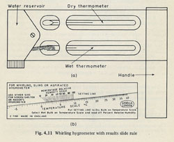
I found a diagram.
This is the Phsychometric Chart, as re-printed in the 'AJ Metric Handbook'
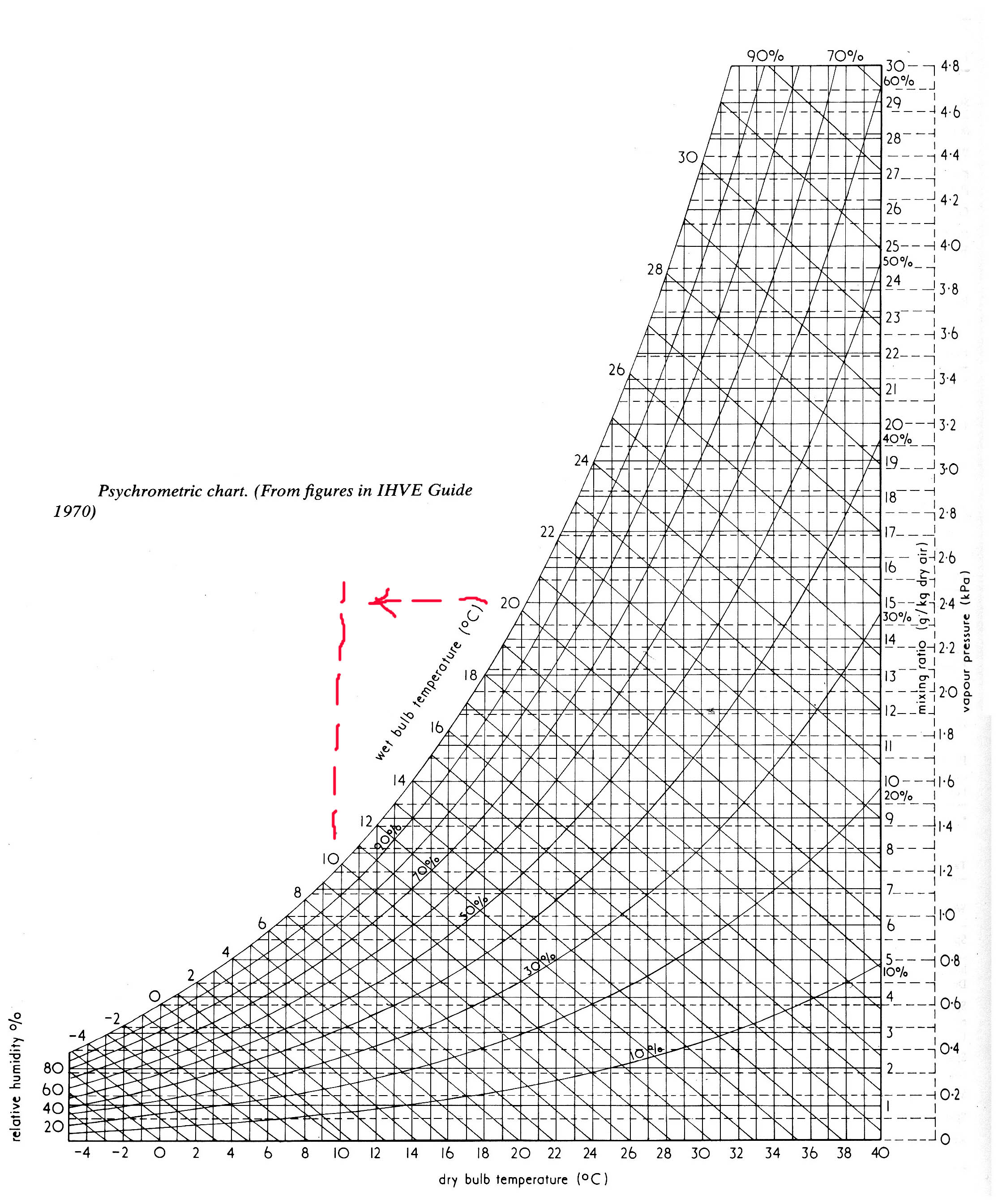
It is not as mad as it looks, the curved lines represent relative humidity. If you follow the right hand axis upwards, you will see that a cubic metre of air at 20degC will support 15gm of water. You drop the temperature to 10degC & it will rain.
You may have noticed the drop in air temperature before rainfall?
The sea fret [humidity, temperature, season]
https://en.wikipedia.org/wiki/Haar_%28fog%29
Clouds:
Time & the Sun:
[I have a dog in this race, I built a latitude specific sundial some 35yrs ago.]
Sun: [Scammonden] 53deg 38' 14"N. The solar maximum altitude on the equinoxes is 90 - 53deg 38' 14"N - point in too many decimal places.
Call it 36deg 12' at the high noon at the equinoxes. The planet spins about 23 and a half deg off true and rotates around the sun once a year. At the summer solstice the sun altitude reaches 36deg 12' + 23 and a half deg, or, 59deg and a half, and winter barely reaches 13deg. This method of predicting noon altitudes works at all latitudes.
Time: [Scammonden] 1deg 55' 36"W. 15deg of the planet's rotation is equal to one hour. 1deg is 4minutes, 1minute of arc is 4seconds of time, 55' is 3.66minutes. add the 36seconds of arc and Scammonden solar noon is about 8minutes after noon at Greenwich.
Time differences became an issue once we had speedy railways, Bristol is some 15minutes behind Greenwich.
Then there is 'the equation of time', the earth has a wobble and refined sundials have a seasonal correction vernier scale. [Waugh Albert E.: Sundials Their Theory and Construction]
Sun, sand, water, pendulums, clock springs & the navigational chronometer!
With the chronometer and Sun angles, we have longitude and time becomes distance.
The 'second' is now defined as related to the wavelength of some atomic particle:
https://en.wikipedia.org/wiki/Second
Getting a broad grasp of our years, calendars of months and days: David Ewing Duncan: 'The Calendar' - a jolly good read.
My Theod [a computer driven EDM, measures distance to devastating accuracy] it relies upon timing the reflected laser signal to calculate the distance - time becomes distance, again. It bursts 3 / 5 signals and averages them, all a bit clever. It used to take days in the office to reduce field notes to coordinates.
Distance:
Napoleon & the metre
'sleepwalkers'
Forecasts & The Meteorological Office:
[For Old Wife's tales, see bottom of page.]
Lots of things happened within a few years: Admiral Fitzroy is kicking about, there is the wreck of the 'Royal Charter' with its memorial at Moelfre [rich people died, you can't swim with gold in your pockets], Morse refines the telegraph, Fitzroy sets up a series of weather stations between Holyhead and Liverpool, The Times publishes the forecasts, Fitzroy establishes the Met Office.
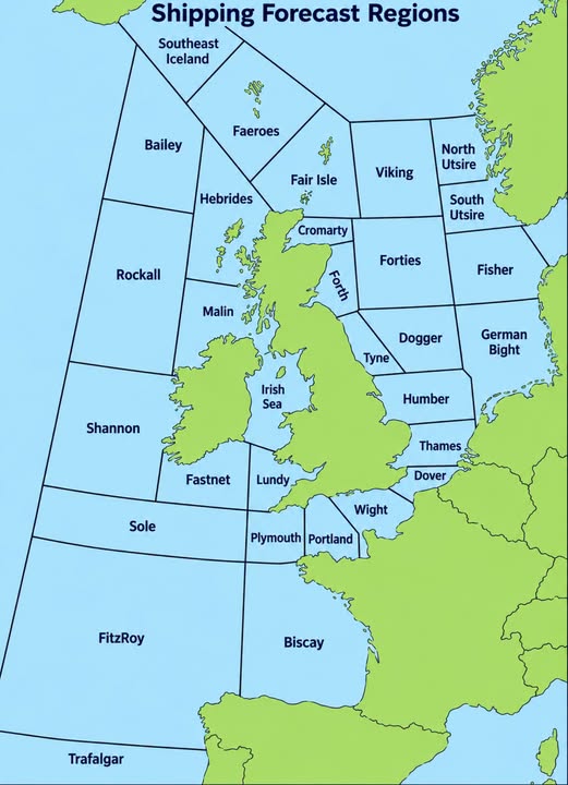
Time: 0048hrs & 0520hrs [long wave & FM]
1201hrs & 1754hrs [long wave]
"In addition, some bulletins include a forecast for all UK inshore waters, as distinct from the coastal waters.
This can be heard on BBC Radio 4 at the end of programmes (approximately 0048), and on BBC Radio 3 at 0535.
The forecast covers the area up to 12 miles offshore and is for the period up to 1800 the next day.
It includes a general synopsis, the forecast of wind direction and force, visibility and weather.
The broadcast on Radio 4 also includes the latest available reports of wind direction and force,
visibility, sea-level pressure and tendency for approximately 20 stations around the UK."
[https://weather.metoffice.gov.uk/guides/coast-and-sea/radio]
Maybe its just me, but most of the scary forecasts seem to be for the 'Irish Sea'!
Met Office https://www.metoffice.gov.uk/
Use an appropriate postcode.
I prefer the overview https://weather.metoffice.gov.uk/maps-and-charts/surface-pressure
There are 'arrows' to show the predicted trend, winds run anti-clockwise around the centre of low pressure.
[We used to have monochrome synoptic charts - I much preferred these.]
XC Weather https://www.xcweather.co.uk/forecast/
Use an appropriate postcode.
I have been conscious of xcweather for over twenty years, it is 'cross country'.
Used by walkers and paragliders.
Cautionary note: the reporting station in Arran is in a valley near to the String Road,
south of Cul Nan Creagan with other hills to the south of the road - this is in an east/west crest of
two valleys. We need to know more about other reporting stations.
Big Salty https://bigsalty.com/en/weather/forecast/343/
This is the link to Warley Moor, there seems to be no direct link to our pond.
There are shortcuts to Dovestones, Clowbridge & Hollingworth.
Remember: altitude and the shape of the hills.
Global Winds https://www.windfinder.com/forecast/west-kirby_marine-lake
About the nearest/appropriate location on their site. Their homepage has an overview of what is
going on - I like that.
Wind Guru - I used to use this, you now have to pay for location information
Synoptic Charts - interpretation
If you stand with your back to the wind and turn about 15o clockwise, hold out your left hand - the centre of the low pressure system lies over there, higher pressure lies on your right. [I thought I had discovered this, again, beaten to it by a feller in the 19th century: Buys Ballot, circa 1857]
Level: [Land, we will get to the sea.]
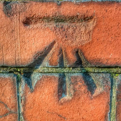
This rather sweetly engraved Ordnance Survey Benchmark into brickwork in Middleton is worthy of appreciation.
I worked for a Wilmslow Cartographer in ~1971, we regularly visited LA Offices to learn the value of the benchmark.
These were usually in feet, we had just started to work in metres. The datum varied with the age of the records.
https://en.wikipedia.org/wiki/Ordnance_datum
Earlier datum was Liverpool and after 1921 was MSL at Newlyn. This is where land dwellers and boaters float apart. Land levels relate to 'mean sea level', marine charts err on the side of caution and relate depths to low spring tide. [I learnt a few years ago that the OS no longer 'maintain' the values of benchmarks. We have gone digital.]
Sea: [the sea is not level]
Prevailing wind and weather is from the West. The Pacific sea level at that end of the Panama Canal [it could have been called the Colon Canal!] is about a foot higher than the Atlantic end of the canal. The wind blown water sweeps around the bottom of Cape Horn. There are notorious tidal rips and whirlpools around the isles in north Scotland as the sea sweeps around into the North Sea.
Gravitational pull also affects the sea level.
https://globalocean.noaa.gov/the-ocean/sea-level/
https://www.bodc.ac.uk/data/hosted_data_systems/sea_level/
https://www.bodc.ac.uk/resources/portals_and_links/sea_level/
https://link.springer.com/article/10.1007/s10236-022-01530-y
https://www.sciencedirect.com/science/article/abs/pii/S0277379107000030
It ain't simple!
There is more: [your boat may sink to differing depths in different places]
Hence the Plimsoll Line
[The memorable basic figures I hold: freshwater weighs 10lb/gall and seawater weighs 10 & three-quarters lb/gall. Nothing is simple: 20 fluid ounces to a UK pint and 16 fluid ounces to US pint - best metric guide is 1000kg to a cubic metre of fresh water.]
Not all seawater has the same density, salinity and temperature affects this, I will wager there other factors.
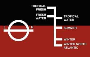
The line L---R refers to Lloyds Register, the design displacement.
Celestial
I can just about remember how to locate the pole star from the plough, after that, I am lost.
For the beginner:
https://nauticalia.com/products/pocket-size-worldwide-star-identifier
sun-spots
equinoctal disruptions
Old Wife's Tales: [and general Folklore]
1. St Swithin's Day falls on July 15 every year.
According to tradition, whatever the weather is like on that day - whether rainy or sunny - it will continue for the next 40 days and 40 nights.
2. "Red sky at night, shepherd's delight, red sky in the morning, sailor's warning."
3. Chaos Theory: "If a butterfly flaps it's wings in the Amazon it can cause a tornado in Texas."
Dr Stephen Lowry, University of Kent [R4, 02/03/17] " Gravity affects everything, down to the smallest particle of dust."
4. "When the cows are lying down in the field, it's going to rain."
5. I heard this said about a windsurf open meeting: 'I don't know why they hold this meeting on this weekend, there is never any wind!' [RVSC]
6. 'Rain before seven, fine by eleven.'
7. 'Mackerel sky and mare's tails make tall ships carry low sails.'
8. 'When the wind is out of the East, 'tis never good for man nor beast.'
9. 'When halo rings Moon or Sun, rain's approaching on the run.'
10. 'Ne'er cast a clout 'til March be out'
11. 'I can smell rain'
12. The rain dance
[I collect these, so if you have anything to add, please let me know.]
Sight
Touch
Sound
There will be other sources - remind me and I will add to the page.
There are so many other sources, please report for inclusion.